
Glacier Rock Lookout Cairns – Where have all the Penguins Gone?
If you stand in Cairns and look towards the hills chances are you’ll find Glacier Rock hard to miss.

Glacier Rock is hard to miss!!
From most places in Cairns you can spot the large slab of rock-face that sits like a sentinel at the entrance of Barron Gorge, stark against all that greenery. So you can imagine the view when you stand at the top of Glacier Rock and look down on Cairns and out towards the Great Barrier Reef. But still my little girl was disappointed……
“BUT mummy” she said looking glum, “where are all the penguins?” It took me a little while to register that the word ‘glacier’ for Charlie must have created an image of ice and snow and frolicking penguins and perhaps even a seal or two. Still, if that’s what had driven her to climb the track for the last hour and a half I was more than happy to take it on the chin.

Only half way there!!
The track to Glacier Rock, although a steady climb upwards (and quite steep in parts) is actually quite easy underfoot, and surprisingly fun for the kids. The path is easy to follow and offers plenty of views to keep everyone’s mind off the fact that you are clearly climbing up, up and more up.The walk to the Glacier Rock Lookout Cairns is extra special for a number of reasons:
It was once part of a network of trails that the Djabugay Aboriginal people used to travel up from the coast to the tablelands. They used the tracks in this area for trade, seasonal food gathering and to visit ceremonial sites.
The track was one of the main routes used by early European settlers (gold miners, cattle drovers and railway workers) to open up the hinterland and connect it with the coast. The Douglas track is a historic trail and along with the Smiths track and the McDonalds track makes up a network of walking tracks through the Barron Gorge National Park.
The views across Cairns and its surrounds are beyond awesome!!
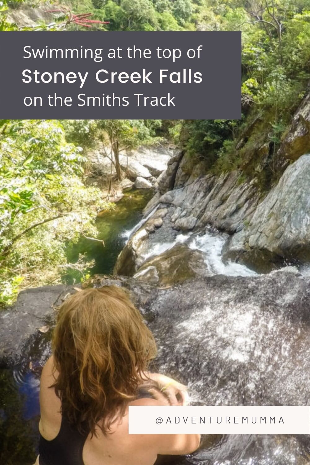
You can take a dip in Stoney Creek Falls at the end of your hike.
The trail is super easy to follow (but very strenuous in parts) and I know of a few friends who have enjoyed a ‘full moon’ hike up to the lookout (don’t forget to bring the torch though ;) ).

The view from the top of Glacier Rock is nothing short of spectacular
The Nitty Gritty Details
We started at Rainforest Estate (on Stoney Creek Road, Kamerunga), a small suburb tucked away at the foot of the Barron Gorge (opposite Lake Placid), and took the Stoney Creek entrance - we liked the fact that you have the option for a dip in the refreshing waters of Stoney Creek upon your return (Please note Rob only went in – after all it was Winter!!). You can also start the walk from the Douglas Track Road, which is also in Rainforest Estate, but you’ll miss the scenery of Stoney Creek and won’t have the option for quick dip if you park here.

Rainforest Estate in Kamerunga is where you’ll find the start of the Track to Glacier Rock
Just after you cross the causeway, or footbridge at the start of Stoney Creek you’ll find a sign for Douglas Track and a path leading off to your right. Follow this track as it leads you away from the creek and meanders gradually upwards through the rainforest. It’s worth remembering (and reminding the children) that you are now walking in the footsteps of gold digging pioneers who clambered up this route on their way to possible riches (or ruins).
The walk uphill through the rainforest will eventually lead you to a massive Mango tree in a clearing. This is the site of an old railway workers campsite and was used as a base during the building of the Kuranda Railway track.
There are some boulders to scramble up here for a nice view BUT monitor the kids closely as the drop on the other side is a tad gnarly. This is the first of the good views down the Barron Valley and worth a look.

Crossing the Kuranda Railway Track
Just a little further on is a footbridge that will take you over the Railway track and up the steep embankment to the other side. It would be great if you could time crossing this bridge with the moment the Kuranda Train makes its journey up. We could hear it coming but it seemed like it had another 30 tunnels to pass through before it reached us. After 5 minutes of waiting we continued upwards…..
Once you’ve crossed the bridge and done the steep set of steps you’ll notice more views. The scenery is great for the kids as it keeps their mind off the upwards slog. You’ll then slowly zigzag up the side of an open hillside to the top where you’ll find a powerline service track. This walk in itself might be enough for the little ones – and you’ll still get awesome views from here.

The service track for the Powerlines is very exposed so make sure you bring a hat!
If the kids (and you) are up for some more walking then continue past the powerline towers to where the Douglas Track meets the McDonalds track (look for the sign). Turn left here to follow the Douglas Track back into the rainforest. It’s a 20-minute steep climb through the rainforest to reach the last sign that will take you to the top of Glacier rock.
Keep a close eye on your kids at this point as its not long before you’re standing on the edge of Glacier Rock taking in the views. And the drop off the ledge is nothing short of scary.

Love the views BUT watch that edge!!
This is a great spot to drag out some food and treats to help the kids refuel before the journey downwards, and in my case get ready to explain where all the penguins have got to…….
Good Things to Know:
It took us 3 hours return to do this walk (and we weren’t rushing).
The best time to do any hiking in Cairns is during the winter months (April – September)
There are many options for longer walks along the Douglas Track. See the map below OR Click HERE for more details.
Mobile phone coverage is unreliable in this area.
Take plenty of drinking water, sunscreen, a hat and insect repellent and wear sensible walking shoes.
Be wary of stinging trees (plants with heart shaped leaves). Do NOT touch. Click HERE for more details.
This area is a National Park so dogs aren’t welcome.
Keep to the tracks, supervise children and stay clear of the cliff edges even if it is a wicked photo opportunity.

Have you done the Glacier Rock walk yet? Have you enjoyed any of the walks in the Barron Gorge?
If you enjoyed reading about this walk you may also like 4 Quick climbs around Cairns for some Cool Views
If you want some BIG walks with BIG views check out 4 Big Climbs for Cairns Views Another walk in the area that may interest you is Swimming at the top of Stoney Creek Falls on Smiths Track Cairns

Hi I’m Kate!
Mumma of 2 young 'uns. Adventurer at Heart. Lover of Tropical Queensland and avoider of Housework and Craft projects - give me the Great Outdoors any day! Come join my family and I as we Explore TNQ.
Latest Blog

Popular Posts


Follow us
@adventuremumma

Grab a copy!

Search the blog
Archive
- Cairns 1
- Cairns Attractions 12
- Cairns Dining 10
- Cairns Esplanade 1
- Family Friendly Accommodation 9
- Activities in Cairns 21
- Beaches & Islands 14
- Cairns Events 7
- Clean Up Australia 1
- Cairns Family Tours 26
- Explore TNQ 101
- Things to do in Cairns 43
- Watersports 26
- Free things to do 9
- Hikes & Walking Trails 10
- Great Barrier Reef Tours 13
- Hot Air Ballooning 1
- Camping Adventures 17
- Family Road Trip 17
- Outback Australia 11
- Parks & Playgrounds 5
- Things to do in Port Douglas 18
- Cairns Northern Beaches 7
- Port Douglas Activities 10
- Travelling with Family 27
- Nature Play 24
- Aboriginal Experiences 2
- Gift Ideas 6
- Freshwater Swimming Holes 10
- Health & Wellbeing 12
- Rainforest Adventures 19
- Family Tips 19
- In the Media 19
- Things to do in Mission Beach 3
- Waterfalls 10
- Sea Kayaking 1
- Explore Australia 21
- Gear Reviews 5
- Gold Coast Activities 2
- Insider Guide 11
- Port Douglas Reef Tours 4
- Things to do in Melbourne 2
- Outback Tours 1
- Port Douglas Dining 6
- Follow the Sun 4
- Kuranda Train & Skyrail 5
- Daintree / Cape Trib Rainforst 4
- Daintree Activities 2
- Things to do in the Daintree 1
- Travel Photography 4